Thursday, August 25, 2011

Hurricane and Tropical Storm Watches Posted

HURRICANE IRENE THREATENS E. COAST

The National Weather Service has posted a Hurricane Watch for a large chunk of the eastern seaboard. At the same time, a Tropical Storm Watch has been posted for the Chesapeake Bay and Tidal Potomac River. This means that hurricane/tropical storm conditions are possible. Continues reading for detailed information. 

A MANDATORY evacuation of Ocean City, MD has been ordered. This evacuation order will go into effect at midnight tonight and all residents are expected to evacuate by 5:00pm tomorrow evening. This includes ALL visitors/tourists. The city will close to any unauthorized personnel tomorrow at 5:00pm. 

Sandbags are being made available in certain jurisdictions along the Tidal Potomac. Also, evacuations are in place in many locations from the Outer Banks of North Carolina into New Jersey. Stay tuned for the latest updates and details. 

The Capital Region Pulse Livestream

Watch live streaming video from capitalregionpulse at livestream.com

Hurricane Irene Threatens East Coast

Hurricane Irene churned off of the southeast coast of the United States Thursday morning. Irene is expected to continue in a northwesterly direction and then change to a northerly direction with time. There is some uncertainty as to where the storm will ultimately end up. However, there has been some shift west with the computer model tracks. Also, Ocean City, MD has started phase one of their emergency plan. They are evacuating international workforce students and asking visitors to postpone trips.

For the DC area, it is unclear how much Irene will impact the area. Please stay tuned to this website AND our Livestream for the most up to date information. We will continue to update our readers with time. Please note that we expect to schedule some live broadcasts using our Livestream channel within the next day or two.

Monday, June 13, 2011

Bomb Threat Disrupts Metro Red Line

Rockville, MD -

Montgomery County Police and other local authorities are wrapping up an investigation after a female Metro passenger made a bomb threat as she exited a Red Line train. According to some witnesses, the woman dropped to her knees in prayer after speaking to somebody on the phone. There were unconfirmed reports that she had just heard about a Muslim bombing in India.

Police have checked the rails and the impacted train and have found no evidence of an actual bomb. The investigation will be wrapping up shortly and service should return to normal as the morning continues.

There are new details emerging with time and we urge our readers to stay tuned for further updates. We are currently attempting to contact Montgomery County officials for a comment.

Saturday, April 16, 2011

Storms with Damaging Winds Possible Today

There will be a risk for severe thunderstorms this afternoon and evening across a large swath of the eastern United States. The risk will be greatest in the Carolina States where there could even be isolated intense tornadoes.

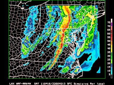
For the Washington, DC area, moderate to at times heavy rainfall will continue this morning before a brief lull later on this morning and early afternoon. A warm front may provide the necessary instability for storms to develop to the west. These storms will intensify and move east during the afternoon hours and into the early evening. Below, you can see one weather models prediction for this evening -

This weather model shows an intense line of thunderstorms for the area late this afternoon. 

Wednesday, March 2, 2011

Park Police Officer in Serious Accident

WTOP is reporting that a park police officer has been involved in a serious accident. Stay tuned for more information.

The officer was allegedly on a motorcycle. This is reported to be on the SE SW Freeway.
Sent on the Sprint® Now Network from my BlackBerry®